Moominmama on Cape Breton Island
Wherein Moominmama explores the Cape Breton Highlands and goes in search of the source of a friend's stories...
The last hurrahs of Tropical Storm Debby are coming across Cape Breton Island at the moment: rain last night, fierce winds today and high humidity.
Moominmama got wet weather when I arrived at the beginning of the week as well, but I did some easy hikes to start and then got one spectacular sunny day when I drove out to White Point, pictured here. Covered in windswept grass and heather, dotted with rocks and facing the deep blue ocean, the water creates endless patterns of white lace against the rocks. White Point has a small cemetery, with a marker seeking the day when loved ones will meet again on God's great shore. Because shore is surely what Cape Breton is all about!
On one cloudy but otherwise good day, Moominmama hiked Mica Hill on the northern end of the Cape Breton Highlands National Park. That took me up bushy hillsides full of wild blueberries (yum!), and at the top of the hill, I found flakes of mica glistening in the sun and white boulders of quartz offering a distant view over the cove. Cape Breton is all capes and coves!
Moominmama also had fun stopping by the North Highlands Community Museum after the hike. In addition to the customary displays about local veterans, a few desks from a one-room schoolhouse and assorted old-fashioned farming and fishing gear, there was a display of fishhooks, some small, some large, that had been surgically removed from folks at the local hospital!
Another surprising item in the collection was a small piece of decorative woodwork from the Titanic, retrieved by a local who'd been involved in rescuing survivors. He kept the bit of wood he'd found in the water, and his family gifted it to the museum. I've come to appreciate local collectors and how many community museums can be found around North America.
One of the things I hoped to collect, picking a day when hikes were inadvisable, was some remnant of the adventurous life of a dear friend who once lived in a converted chicken coop on a farm on Cape Breton Island. When I was 19, I started an internship, and a group of my colleagues had gone out to eat when I overheard this woman talking to someone else about her teens on the island. I was immediately intrigued and made a point of cornering her later to find out more. We've been friends ever since.
So coming to the island, I wanted to scope out her old stomping grounds. I had the name of a road and a Google search result so set out in foggy weather to see what I could find. I couldn't find the road I was looking for, but I did find some locals gathered at the fire station, setting it up for a Saturday night event. They rallied the eldest among them to see if anyone remembered my friend or the farm where she stayed.
One of the problems in identifying the land where this chicken coop stood is that road names had been changed. My Google result was not accurate, and the locals couldn't call up from memory which property was involved.
Still, I knew my friend had lived in the town of Grand River, and I got a few photos to share, including this view up the river from an old bridge in town that I expect she must have crossed. I also got a sense of the immense woods, scattered farmhouses, spruce and summer goldenrod, the presence of both the ocean and the giant Bras D'Or lake. The fog was also authentic, I bet!
As long as I was in the area, I paid a visit to the St. Peter's Canal. This is an area of the island that began to be developed as early as the 1500s by the Portuguese, who called it San Pedro. The French came next in 1650 and called it Saint Pierre. They traded with the Mi'kmaq during the booming fur trade. For about 45 years in the first half of the 1700s, it was known as Port Toulouse, and now it's Saint Peters. I'm sure the Mi'kmaq had their own name for it as well.
But it was valuable real estate because it had access to both the Atlantic Ocean and the Bras D'Or ("arm of gold") estuary, which is huge! The estuary touches much of the inland of the southern half of the island so furs could be transported to transatlantic ships by making this short crossing. The portage route was dug out in 1854 to create a canal, which remains today with two small locks between the lake and the ocean to make it easy for boats to travel in between. The Bras D'Or region is unique in its salt water/freshwater environment, which is why it's a UNESCO Biosphere Reserve.
Moominmama started out her stay in the Cape Breton Highlands to the north but is now in a provincial park nearer the city of Sydney. That's for two reasons. The campground further north proved noisy, and I wasn't getting enough sleep. Plus this location puts me closer to the ferry I take on Monday to get to Newfoundland!
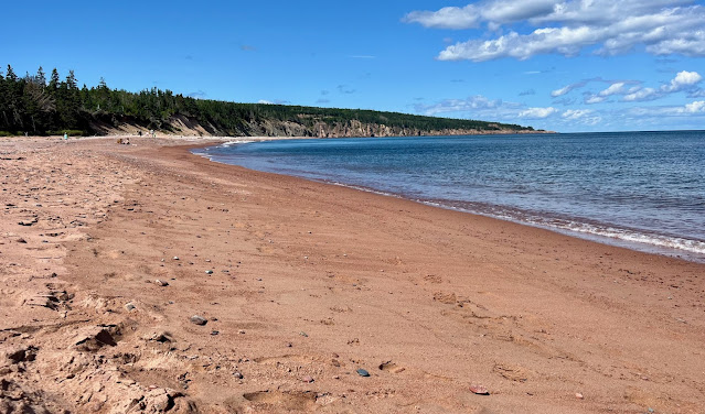
For now, I'm waiting for the weather to ease up, but I did get out swimming a few times in the crystalline waters near the highlands. Here's "my" beach on that one glorious sunny day! I'm not sure what I'll get for connectivity in Newfoundland. It's been spotty here in Cape Breton. If I don't post next week, fear not. I'll have some great pictures to post eventually from the next leg of my trip!


Comments
Post a Comment